Warning: Spoiler Alert for Jurassic World Dominion
Mosasaur Tracker
A 6 hour, 35 minute Product Design Challenge
I've chased sharks while snorkeling, oogled lions up close on safari, and been chased by 1,500 + lb animals in my own backyard without any trouble. However, as a frequent sailor and ocean enthusiast, I was haunted by the release of the Mosasaur in Jurassic Park: Fallen Kingdom.
I was kept up at night wondering how I would cope if this were a real problem. The ocean is dangerous, but a 56 foot long, carnivorous, pre-historic monster that could cover 100 miles in a day lurking in it would make it significantly more so. Even if the creature itself wasn't that dangerous to humans, people are fearful, and it could have a huge impact on the communities that spend their time on the water.
How could we feel safe on the water, while preserving a one of a kind back from extinction species?
One morning I woke up and put two and two together; every original creature in Jurassic World has a tracking device, and that tracking device could be brought back online.
The solution was simple: A Mosasaur Tracking App would allow people to enjoy the water and safely avoid the problem. This app could be connected to an external waterproof tag that vibrates and flashes lights when the mosasaur is within a chosen radius.
I decided this would be a perfect opportunity for a design challenge:
The Goal was to make as much progress as possible designing a Mosasaur Tracking app in the amount of time it takes to watch all three Jurassic World Films.

Start to Finish
Watch the Entire Design Process
Six hours and thirty-five minutes of Design, condensed into three minutes and forty-seven seconds.
Want to see a bit more detail? Watch the ten minute version here.
Continue below to read the Case Study.
Target Users:


Personas and User Empathy
I may have been on a time crunch, but I still found it valuable to take the time to lay a good foundation before jumping into the app.
While pretty formatting needed to be sacrificed, I still took a few minutes to put some personas together.
Meet Dave, a commercial fisherman who doesn't want to get chomped like the crew at the beginning of Jurassic World Dominion, and Leilani, a free spirited surfer who won't be kept off the waves even if other surfers have met their demise in the jaws of the Mosasaur.
In addition, I brainstormed other potential user groups.
-
Teachers who want to engage their young students.
-
Researchers who want to study migratory patterns of a one of a kind creature without getting in the water.
-
Hobbyists with an interest in the mosasaur.
-
Anyone who likes being out on the water-sailors, boators, surfers, swimmers, travelers.
-
Worried or interested parents with children living near the coast.
-
Problem users; Poachers and 'hunters'.
Competitive Audits
I found several indirect competitors to take a look at.
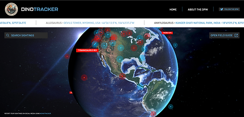
One of my most direct competitors was Dinotracker.com, a Jurassic World Dominion themed movie promotion project.
Featuring beautiful UI, it is a fun, pretty, and entertaining place to poke around. Unfortunately high quality images make the site slow to load. The format is also for a larger desktop; which made it a little overwhelming on a laptop screen.
The Dino Tracker webpage features times and dates of sightings along with some footage of dinosaurs. Dinosaurs are categorized by aggression level, size, and diet. Sightings are contributed by bystanders reporting to the DPW, or Department of Prehistoric Wildlife.
While this project is very similar, ultimately its end value is for entertainment. A 'real' product for dinosaur tracking would likely need to be mobile, give proximity alerts, and have more real world safety features.


The OCEARCH Shark Tracker was my other most direct competition.
I found this app to be delightful. It featured:
-
A clear map with shark icons on location.
-
Ping times and locations.
-
Names for individual sharks.
-
Individual shark paths.
-
Sharks listed by name with their personal information.
-
Articles and news.
-
The ability to favorite specific sharks.
I loved this app and found it very inspiring. There's just no beating the ability to favorite sharks by name. I enjoyed the friendly, educational tone and the encouragement for ocean preservation this app provided.
I also took a look at two marine safety apps.
The National Oceanic and Atmospheric Administration is the number one reliable resource for weather and climate information in the United States. I downloaded their app to get a look at how mariners can safely navigate foul weather via app.
While chocked full of useful information, the NOAA app was difficult to read. The tutorial felt obnoxious, basic settings (like choosing location) weren't available/easy to find, the screen felt cluttered and overwhelming, and paywall blocked features were taking up one of the most useful icon locations.
TZ iBoat is a marine navigation app aimed towards helping sailors, cruisers, and fisher people plan outings easily.
A variety of useful features include:
-
Map overlay options for preferred views of ocean phenomenon.
-
Ability to set marks and positions on your map.
-
Offline charts and weather.
-
Cruising and trip planning and tracking organization.
Unfortunately lots of paywalls make this app difficult to use for free, and it does talk to the user, which could be unsettling.


Takeaway
One thing in common the most useful of these apps had was the largest, most accessible map possible, with menus easily hidden to make room on screen. When moving forward with the design process, I knew a large map would be my home screen, and finding ways to make menus out of the way yet easy to find would be crucial.
OCEARCH Shark Tracker also highlighted the need for for extra features to help people learn and become interested and invested in wildlife. The friendly mood brought me back to one of the core needs both apps were working to fulfill; soothing fears around large, dangerous, and endangered marine animals.
The User Journey

The User Journey Map for this App was relatively simple.
Key Functions included:
-
Looking at the current mosasaur location on a map.
-
Seeing the mosasaurs previous path and setting dates to view old paths.
-
Bluetooth settings for the external warning device.
-
Articles and education on the Mosasaur and other dinosaurs.
-
Location settings.
-
Community Board for posting sightings.*
*This could be significantly expanded upon with additional features and terrestrial prehistoric animal features, or eventually become a seperate app.
Wireframe Sketches


Mockups and Prototype


Next Steps
With more time, my first priorities for this project would include:
-
Perfecting art and graphics.
-
Adding details like latitude and longitude lines to the map.
-
More screens to expand settings for bluetooth devices and location.
-
Fleshing out more screens to make for functional community building in the dinosaur spotting section.
Further growth of this app could include tracking all prehistoric animals, including tracking by sightings. Bluetooth connected devices like tags and bracelets could have panic buttons to alert nearby folks when a dangerous prehistoric animal is sighted.
An expansion of the community forum into a general prehistoric wildlife spotting and tracking forum would also prove valuable. Building a community to promote safety and spark conversation about prehistoric wildlife would encourage the populace of Jurassic World to not only accept the new reality of sharing their world but also appreciate, enjoy, and study their new neighbors on earth.